
Our modern world has made a giant technological leap, with drones becoming an integral part of various industries. A critical factor in their operation lies in robust navigation systems – namely, the Global Positioning System (GPS) and Russia’s Global Navigation Satellite System (GLONASS).
Understanding GPS: Decoding the Global Positioning System
Birth of GPS: A Glimpse into History
Conceptualized by the US Department of Defense in the 1970s and fully operational by 1995, GPS has revolutionized the concept of location and navigation. The system operates on a constellation of 24 satellites, offering global coverage and providing geo-spatial positioning with incredible accuracy.
How GPS Works: Simplifying Satellite Navigation
Fundamentally, GPS operates on a principle called trilateration. By receiving signals from at least three GPS satellites, a receiver calculates its precise location on Earth. The intersection point of the spheres around these satellites signifies the receiver’s exact position.
Benefits of GPS in Drones: Beyond Geolocation
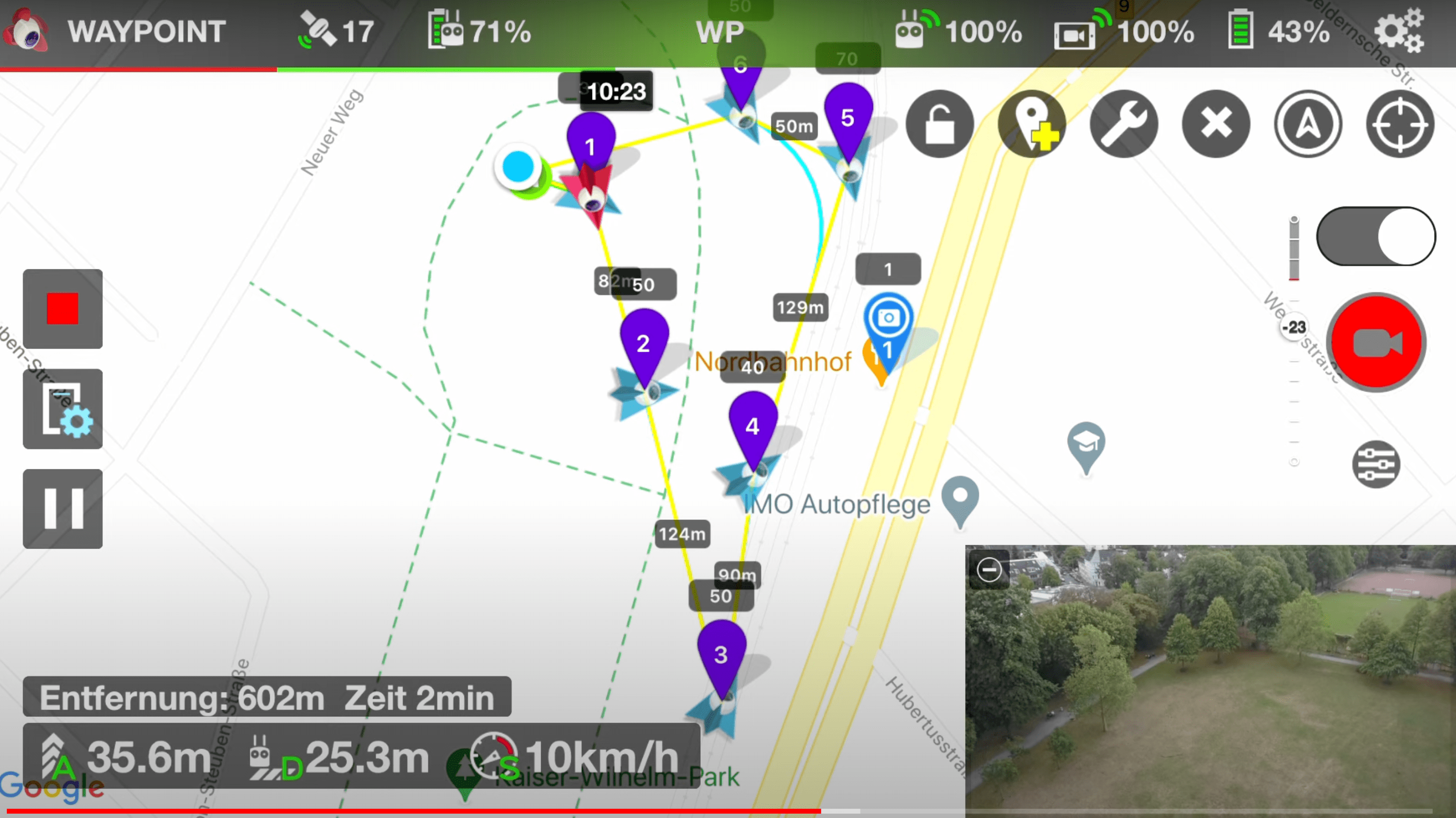
GPS provides drones with crucial navigational data, enabling autonomous flight and precision landing. It also allows for geofencing – a technology that restricts drones from entering specific geographical areas, thereby enhancing safety and security.
Unveiling GLONASS: Russia’s Answer to GPS
GLONASS Explained: From Inception to Implementation
GLONASS, a system developed by the Soviet Union during the same era as GPS, operates on a similar principle. With a constellation of 24 satellites, it covers the globe, providing precise geolocation services.
Working Mechanism of GLONASS: Diving Deeper into the Technology
Like GPS, GLONASS uses trilateration for positioning. However, it operates on a higher frequency and a slightly different coding method, reducing the risk of signal interference and potentially increasing the accuracy of positioning in certain conditions.
Why GLONASS Matters: Advantages in Drone Technology
GLONASS provides an additional layer of reliability to drones. In areas where GPS signals may be weak or unavailable, GLONASS ensures continued navigation, leading to enhanced functionality and flight safety.
GPS vs GLONASS: The Battle of Navigation Systems
Comparing the Tech: Strengths and Weaknesses
While both systems operate similarly, the geographical location affects their efficiency. For instance, GLONASS performs better at high latitudes, making it more effective in the northern hemisphere.
Coverage and Accuracy: A Global Perspective
Both systems offer global coverage, but their combined use can increase positioning accuracy, beneficial in professional applications such as surveying and mapping.
Implications for Drone Users: Which One to Choose?
Choosing between GPS and GLONASS isn’t necessary. Modern drones can leverage both systems simultaneously, enhancing navigational precision and reliability.
Dual Navigation: Leveraging Both GPS and GLONASS in Drones
Dual Navigation Defined: Best of Both Worlds
Dual navigation allows drones to receive signals from both GPS and GLONASS satellites. This redundancy enhances positional accuracy and ensures uninterrupted operation, even if one system fails.
Upsides of Using GPS and GLONASS Simultaneously
Combining GPS and GLONASS mitigates the limitations of each system, ensuring accurate geolocation, enhancing flight stability, and reducing the risk of lost drones.
Configuring Drones for Dual Navigation: A Step-By-Step Guide
Modern drones typically come with dual navigation capability. Enabling this feature often involves a simple switch in the drone’s control software, allowing it to utilize both GPS and GLONASS signals.
Enhancing Drone Capabilities: Real-World Applications of GPS and GLONASS
Drones in Geolocation Services: Mapping the World from Above
Drones equipped with GPS and GLONASS are used in topographic surveys, archaeological exploration, and environmental monitoring, providing detailed and accurate geographical data.
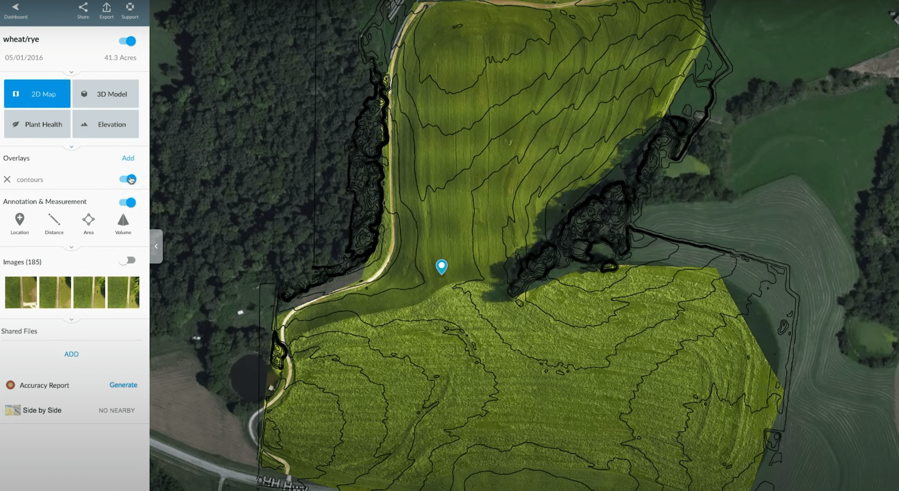
Precision Agriculture: Sowing Seeds of Efficiency with Drones
These navigation systems enable drones to monitor crop health, manage livestock, and optimize irrigation, revolutionizing the agriculture sector.
Search and Rescue Operations: Drones as Lifesavers
GPS and GLONASS-equipped drones are invaluable in search and rescue missions, reaching inaccessible areas and providing accurate location data to aid in rescue operations.
Drone Delivery: The Future of Logistics
The e-commerce industry is eyeing drones for delivery services. Accurate navigation systems ensure reliable and precise deliveries, pushing the boundaries of conventional logistics.
Regulatory Considerations: GPS, GLONASS and Drone Laws
Navigating International Airspace: Understanding Regulatory Boundaries
Understanding local and international laws is crucial for drone operators. Regulations vary, with some countries requiring drone registration, flight approvals, and compliance with no-fly zones.
Privacy Concerns: The Intricacies of Satellite Tracked Drones
With drones becoming increasingly ubiquitous, privacy concerns are rising. Both industry and regulators are grappling with how to balance the benefits of drones with the need to protect privacy.
Conclusion: GPS and GLONASS in Drones: A Navigational Leap Forward
Reflections on the Impact of GPS and GLONASS on Drone Technology
The integration of GPS and GLONASS in drones has had a transformative impact on various industries, offering new ways to gather data, deliver goods, and save lives. The enhanced reliability and precision these systems provide have been instrumental in propelling the drone industry forward.
Looking Ahead: The Future of Drone Navigation Systems
As we look to the horizon, the future of drone navigation is promising. With the advent of new technologies like Galileo (EU) and BeiDou (China), drones will continue to become more precise, reliable, and valuable in an increasing number of applications.